
Abstract
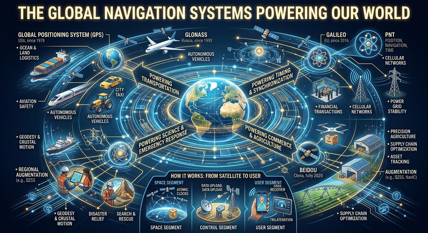
Global navigation has evolved from maps, stars, magnetic compasses, radio beacons, and terrestrial surveying into one of humanity’s most sophisticated space-based infrastructure systems. Today, Global Navigation Satellite Systems (GNSS) provide positioning, navigation and timing (PNT) services to billions of users and support transportation, telecommunications, agriculture, emergency response, surveying, finance, scientific research and critical infrastructure.
GNSS is not a single system. It is an international ecosystem containing several independent satellite constellations. The principal global systems are the United States’ Global Positioning System (GPS), the European Union’s Galileo, Russia’s GLONASS, and China’s BeiDou Navigation Satellite System (BDS). Regional systems include India’s NavIC and Japan’s Quasi-Zenith Satellite System (QZSS). (Federal Aviation Administration)
The importance of these systems extends far beyond showing a blue dot on a smartphone map. Their deeper function is to establish a highly accurate, globally available reference for where something is, how fast it is moving, and what time it is. GPS, for example, is formally described as a positioning, navigation and timing utility and is composed of space, control and user segments. (GPS)
1. Introduction
Modern civilization depends on an invisible infrastructure of satellites orbiting hundreds or thousands of kilometres above Earth.
When a smartphone determines its location, when an aircraft follows a navigation route, when a farmer maps a field, when a ship crosses an ocean, or when infrastructure is precisely surveyed, satellite navigation may be involved.
The technology is collectively known as Global Navigation Satellite Systems, or GNSS.
The fundamental idea is elegant:
A receiver determines where it is by measuring the arrival time of precisely timed radio signals transmitted by satellites whose positions are known.
Because radio signals travel at approximately the speed of light, extraordinarily small timing errors can translate into significant positioning errors. GNSS therefore represents a remarkable combination of:
- orbital mechanics;
- radio engineering;
- atomic clocks;
- relativity;
- telecommunications;
- geodesy;
- computer science;
- signal processing;
- mathematics;
- Earth science;
- cybersecurity;
- and international cooperation.
2. What Is GNSS?
GNSS is the general term for satellite-based positioning, navigation and timing systems.
GPS is therefore one GNSS, not the name of every satellite navigation system.
The major distinction is:
| System | Operator | Coverage |
|---|---|---|
| GPS | United States | Global |
| Galileo | European Union | Global |
| GLONASS | Russian Federation | Global |
| BeiDou | China | Global |
| NavIC | India | Regional |
| QZSS | Japan | Regional, complementary to GPS |
GPS.gov identifies Galileo, GLONASS, BeiDou, NavIC and QZSS among the major other GNSS systems. (GPS)
A modern receiver can often combine signals from multiple constellations. This is called multi-GNSS.
Instead of depending upon only one satellite network, a receiver can use compatible GPS, Galileo, BeiDou, GLONASS and regional-system signals where available.
That increases the number of observable satellites and can improve availability and positioning performance.
3. The Three Fundamental GNSS Functions
GNSS can be understood through three fundamental functions:
3.1 Positioning
Determining:
- latitude;
- longitude;
- altitude;
- and, with appropriate techniques, much more precise relative position.
3.2 Navigation
Using position and velocity information to determine:
- direction;
- distance;
- route;
- speed;
- trajectory;
- and movement.
3.3 Timing
Providing extremely precise time synchronization.
This third function is often overlooked.
GPS satellites carry atomic clocks, and their timing information can synchronize receivers without each user needing to operate an atomic clock. GPS.gov notes applications including communications systems, power grids, financial networks and other critical infrastructure. (GPS)
Therefore:
GNSS is simultaneously a navigation system and a global time-distribution infrastructure.
4. The Architecture of a Global Navigation System
A GNSS can be understood as a giant technological architecture:
Space segment → Radio signals → Ground/control infrastructure → Receiver → Algorithms → Position/time
GPS provides a particularly clear example.
Its architecture has three principal segments:
- Space segment
- Control segment
- User segment
GPS.gov describes these three segments explicitly. (GPS)
5. The Space Segment
The space segment consists of navigation satellites.
These spacecraft contain:
- highly stable clocks;
- navigation signal generators;
- antennas;
- computers;
- power systems;
- communications systems;
- orbital-control equipment;
- and redundant components.
A satellite continuously broadcasts information about:
- its time;
- orbital position;
- system status;
- and navigation information.
The receiver does not normally need to communicate with the satellite to obtain the basic positioning measurement.
This is fundamentally a one-way navigation signal.
6. Why Satellites Are Necessary
Imagine trying to determine your position on Earth using fixed reference points.
If you knew your distance from one point, you could be somewhere on a circle around it.
If you knew your distance from two points, the possibilities would become much smaller.
With three-dimensional measurements from several known reference points, the receiver can determine its location.
This is the principle of trilateration.
GPS.gov explains that positioning is based on the relationship:
Distance = speed × time
Since radio signals travel at the speed of light, measuring their travel time allows the receiver to estimate its distance from a satellite. (GPS)
7. Trilateration Versus Triangulation
A common misconception is that GPS primarily uses triangulation.
The basic measurement is actually distance, not angle.
Therefore the fundamental concept is trilateration.
The receiver estimates the range to multiple satellites and finds the position that satisfies those range measurements.
In simplified form:
Satellite position + signal travel time → satellite-receiver range
Multiple ranges:
Range 1 + Range 2 + Range 3 + Range 4 → receiver position and clock correction
8. Why Four Satellites Are Normally Important
A receiver must determine several unknown quantities.
For a basic three-dimensional solution, these include:
- X position;
- Y position;
- Z position;
- receiver clock error.
That produces four unknowns.
Consequently, a basic GNSS solution generally benefits from observations from at least four satellites.
The FAA explains that a fourth satellite allows the receiver to determine latitude, longitude, altitude and time without requiring the receiver itself to contain an atomic clock. (Federal Aviation Administration)
Modern receivers commonly observe many more than four satellites.
More observations can help improve robustness and enable sophisticated error correction.
9. Atomic Clocks: The Hidden Heart of GNSS
One of the most extraordinary components of GNSS is the atomic clock.
Navigation satellites require exceptionally precise timing because an error in signal timing becomes an error in estimated distance.
The basic relationship is:
Distance error = signal speed × timing error
Since electromagnetic signals travel at approximately:
299,792,458 metres per second
even a very small timing error can become a substantial distance error.
GPS satellites therefore carry highly accurate atomic clocks. (GPS)
Atomic clocks are based on extremely stable physical transitions within atoms.
They provide the reference against which the receiver measures signal timing.
10. Relativity and Satellite Navigation
GNSS is also a practical demonstration of Einstein’s theories of relativity.
Satellite clocks experience conditions different from clocks on Earth’s surface because of:
- their orbital velocity;
- and the difference in gravitational potential between the satellite and Earth.
Special relativity and general relativity therefore affect satellite clock rates.
If these effects were ignored, navigation errors would accumulate rapidly.
GNSS is consequently one of the clearest examples of fundamental physics becoming an everyday technology.
11. The Control Segment
Satellites cannot simply be launched and forgotten.
Ground infrastructure continuously monitors the constellation.
The control system:
- tracks satellites;
- monitors their health;
- determines orbital parameters;
- monitors clock performance;
- uploads navigation information;
- performs orbit corrections;
- detects anomalies;
- and maintains constellation performance.
GPS.gov describes the control segment as worldwide monitoring and control infrastructure responsible for maintaining satellite orbits and clocks and uploading updated navigation data. (GPS)
This creates a continuous loop:
Satellite → ground monitoring → analysis → updated navigation information → satellite → user
12. The User Segment
The user segment is everything that receives and processes GNSS signals.
Examples include:
- smartphones;
- vehicle navigation systems;
- aircraft avionics;
- marine navigation equipment;
- agricultural machinery;
- surveying instruments;
- timing equipment;
- scientific instruments;
- drones;
- industrial systems;
- wearable devices;
- and spacecraft.
A GNSS receiver generally performs several major operations:
- Searches for satellite signals.
- Identifies satellites.
- Synchronizes with their signals.
- Decodes navigation data.
- Measures signal timing.
- Calculates ranges.
- Determines the receiver’s position and time.
- Applies corrections.
- Produces navigation information for applications.
13. The Radio Signal
GNSS satellites transmit precisely structured radio signals.
The signal contains information that enables the receiver to determine:
- which satellite transmitted it;
- when it was transmitted;
- where the satellite was;
- and other information necessary for positioning.
The receiver compares the expected transmission time with the observed arrival time.
The difference provides an estimate of signal travel time.
14. The Earth’s Atmosphere Creates Errors
GNSS signals do not travel through empty space.
Between satellite and receiver lies Earth’s atmosphere.
The signals can therefore experience propagation effects.
Two important regions are:
Ionosphere
The ionosphere contains electrically charged particles that affect radio-wave propagation.
Troposphere
The troposphere is the lowest layer of the atmosphere and introduces additional propagation effects.
The FAA notes that receivers account for propagation delays associated with the ionosphere and troposphere. (Federal Aviation Administration)
Sophisticated GNSS systems use atmospheric models, multiple frequencies and correction services to reduce these errors.
15. Multipath
Another major error source is multipath.
A signal may reach a receiver:
- directly from the satellite;
- and indirectly after reflecting from buildings, terrain, vehicles or other surfaces.
The receiver can therefore observe several versions of the same signal.
This is particularly important in:
- cities;
- canyons;
- industrial areas;
- forests;
- mountainous environments.
Modern receiver designs and algorithms attempt to identify and reduce multipath effects.
16. GPS: The American GNSS
The Global Positioning System (GPS) is the United States’ satellite navigation system.
It evolved from military satellite-navigation research and became a global utility for positioning, navigation and timing.
GPS consists of:
- space;
- control;
- and user segments. (GPS)
Its signals are used throughout civilian society as well as government and professional applications.
NASA notes that the system’s origins can be traced to the Sputnik era and Doppler-based satellite tracking, while development accelerated through U.S. defense programs in the late twentieth century. (NASA)
17. Galileo: Europe’s Global Navigation System
Galileo is the European Union’s global satellite navigation system.
Unlike GPS, which is a U.S. system, Galileo represents Europe’s independent capability in global satellite navigation.
Galileo provides:
- Open Service;
- High Accuracy Service;
- Public Regulated Service;
- Search and Rescue;
- navigation-message authentication;
- and timing services. (EU Agency for the Space Programme)
One particularly important development is OSNMA — Open Service Navigation Message Authentication.
Authentication helps receivers determine whether navigation information genuinely originates from the Galileo system and has not been modified. (EU Agency for the Space Programme)
This is increasingly important in a world concerned with signal spoofing and navigation-system resilience.
18. GLONASS: Russia’s Global System
GLONASS, or Global Navigation Satellite System, is Russia’s global satellite navigation constellation.
GPS.gov identifies GLONASS as a global GNSS owned and operated by the Russian Federation. (GPS)
GLONASS provides another independent source of satellite-navigation signals.
Modern multi-GNSS receivers can use compatible GLONASS signals alongside other constellations.
19. BeiDou: China’s Global Navigation System
BeiDou Navigation Satellite System (BDS) is China’s global satellite navigation system.
It evolved through several generations from a regional capability into a global navigation infrastructure.
GPS.gov lists BeiDou among the major global GNSS constellations and reports an operational constellation of more than 30 satellites. (GPS)
BeiDou is strategically important because it provides China and international users with an independent global PNT capability.
20. NavIC: India’s Regional Navigation System
India developed NavIC, formerly called IRNSS.
It was designed primarily to provide positioning and navigation coverage over India and surrounding areas.
GPS.gov describes NavIC as a regional system covering India and an area extending approximately 1,500 km around the Indian mainland. (GPS)
NavIC demonstrates an important principle:
A country does not necessarily need a fully global constellation to create strategically useful navigation capability.
21. QZSS: Japan’s Regional System
Japan operates the Quasi-Zenith Satellite System (QZSS).
QZSS complements GPS and is designed to improve navigation coverage in Japan and surrounding areas.
GPS.gov identifies QZSS as a Japanese regional GNSS that complements GPS in East Asia and Oceania. (GPS)
Its orbital design is particularly valuable in environments where conventional satellite geometry can be challenging.
22. Why Multiple GNSS Systems Matter
A receiver using only one constellation may have limited satellite visibility at a particular moment.
A multi-GNSS receiver can potentially observe satellites from:
- GPS;
- Galileo;
- BeiDou;
- GLONASS;
- QZSS;
- NavIC.
This creates a much larger measurement environment.
The advantages can include:
- greater availability;
- better satellite geometry;
- improved reliability;
- improved performance in difficult environments;
- greater resilience;
- and potentially higher accuracy.
Galileo’s own documentation notes that interoperability with other GNSS increases service reliability. (EU Agency for the Space Programme)
23. GNSS and Smartphones
The smartphone transformed GNSS from a specialist technology into an everyday utility.
Modern smartphones can combine:
- GNSS;
- Wi-Fi positioning;
- cellular networks;
- inertial sensors;
- digital maps;
- barometers;
- cameras;
- and software algorithms.
This creates a hybrid positioning environment.
The result is much more than traditional GPS.
The phone can estimate:
- location;
- movement;
- direction;
- speed;
- altitude changes;
- and route.
24. GNSS and Transportation
Transportation is one of the largest beneficiaries.
Road transportation
GNSS supports:
- navigation;
- fleet management;
- route planning;
- logistics;
- traffic analysis;
- emergency response;
- asset tracking.
Aviation
Satellite navigation supports:
- aircraft navigation;
- route management;
- approach procedures;
- surveillance;
- timing;
- and increasingly sophisticated precision-navigation applications.
Maritime transport
Ships use satellite navigation for:
- ocean navigation;
- port approaches;
- route planning;
- surveying;
- logistics;
- and fleet management.
25. GNSS and Agriculture
Modern agriculture is increasingly dependent on precision positioning.
GNSS can support:
- field mapping;
- machine guidance;
- precision planting;
- fertilizer application;
- spraying;
- harvesting;
- yield mapping;
- soil sampling;
- and agricultural surveying.
When GNSS is combined with sensors, satellite imagery, artificial intelligence and farm-management software, agriculture becomes a data-driven system.
This is particularly important for large-scale farming.
26. GNSS and Construction
Construction companies use high-precision GNSS for:
- surveying;
- site mapping;
- machine guidance;
- earthmoving;
- grading;
- infrastructure alignment;
- road construction;
- and monitoring.
High-end systems can achieve far greater precision than ordinary consumer navigation.
Techniques such as Real-Time Kinematic (RTK) use correction information to dramatically improve positioning.
27. GNSS and Geodesy
Geodesy is the scientific study of Earth’s:
- shape;
- size;
- gravitational field;
- and changing surface.
GNSS provides a global reference framework for measuring Earth.
Scientists can use extremely precise GNSS observations to investigate:
- tectonic movement;
- crustal deformation;
- earthquakes;
- volcanic activity;
- sea-level change;
- glacier movement;
- and other geophysical processes.
GNSS therefore functions as an enormous scientific measuring instrument.
28. GNSS and Telecommunications
Telecommunications networks require synchronization.
Modern networks depend on precise timing for:
- frequency synchronization;
- network coordination;
- timestamping;
- cellular infrastructure;
- and other timing functions.
GPS.gov highlights precise timing and synchronization for communications infrastructure. (GPS)
This demonstrates a critical point:
A GNSS receiver does not have to use navigation information to be valuable.
Sometimes its most important output is simply:
time.
29. GNSS and Electrical Power Grids
Electrical grids require accurate synchronization across geographically separated infrastructure.
Precise timing helps operators coordinate measurements and analyze system behavior.
GNSS-based timing can therefore contribute to:
- synchronized measurements;
- grid monitoring;
- fault analysis;
- system coordination;
- and infrastructure management.
The broader lesson is that satellite navigation has become embedded in infrastructure that most people never associate with navigation.
30. GNSS and Financial Systems
Financial infrastructure also benefits from accurate time.
Transactions, communications and market activities require reliable timestamps and synchronization.
GNSS timing can contribute to:
- timestamp synchronization;
- network timing;
- financial infrastructure;
- data-center synchronization;
- and regulatory record keeping.
The value here is not knowing where an asset is.
It is knowing exactly when something occurred.
31. GNSS and Emergency Services
Emergency response depends heavily on location.
GNSS can help identify:
- emergency callers;
- vehicles;
- aircraft;
- ships;
- field personnel;
- disaster-response teams;
- and remote assets.
Galileo also provides a dedicated Search and Rescue service designed to contribute to international distress-response systems. (EU Agency for the Space Programme)
32. GNSS and Scientific Space Operations
GNSS is not limited to Earth’s surface.
Spacecraft can also use GPS and related navigation techniques.
Applications include:
- orbit determination;
- spacecraft navigation;
- timing;
- formation flying;
- satellite operations;
- and scientific missions.
GPS.gov documents applications ranging from spacecraft navigation and orbit determination to satellite formation flying and launch-vehicle tracking. (GPS)
33. GNSS and Drones
Uncrewed aircraft commonly use satellite positioning for:
- navigation;
- waypoint following;
- mapping;
- surveying;
- agricultural monitoring;
- infrastructure inspection;
- and research.
However, GNSS is normally only one part of a modern navigation architecture.
Other sensors can include:
- inertial measurement units;
- cameras;
- radar;
- barometers;
- optical-flow systems;
- and other positioning technologies.
This creates sensor fusion.
34. High-Precision GNSS
Ordinary consumer positioning and professional surveying are very different.
Consumer positioning may provide metre-scale location.
Professional systems can achieve:
- centimetre-level;
- and, under suitable conditions, even more precise relative measurements.
Techniques include:
RTK
Real-Time Kinematic positioning uses correction information to reduce errors.
PPP
Precise Point Positioning uses precise satellite orbit and clock information without requiring a nearby conventional reference station in the same way as RTK.
Differential GNSS
A reference receiver helps estimate errors that can then be applied to another receiver.
These techniques transformed GNSS from a general navigation system into a precision measurement technology.
35. GNSS Augmentation
GNSS can be enhanced by additional systems known as augmentation systems.
Examples include:
- ground-based augmentation;
- satellite-based augmentation;
- regional correction networks;
- local reference stations.
Europe’s EGNOS, for example, is designed to improve GPS performance and provide information about system reliability for users in Europe. (European Space Agency)
Augmentation is particularly important when positioning must meet strict performance requirements.
36. GNSS Integrity
Accuracy is not the only requirement.
For safety-critical applications, users also need to know:
Can I trust this navigation solution?
This is called integrity.
A navigation system can be highly accurate but still problematic if it fails to warn users when the solution becomes unreliable.
This is especially important in aviation.
Galileo has developed services designed around integrity, authentication and resilience. (European Space Agency)
37. GNSS Security
Satellite navigation signals are weak by the time they reach Earth.
This creates security challenges.
Two major concepts are:
Jamming
Interference attempts to make navigation signals difficult or impossible to receive.
Spoofing
False signals attempt to deceive a receiver about its position or time.
These risks are increasingly important because navigation information is integrated into critical infrastructure.
Modern GNSS development therefore increasingly considers:
- authentication;
- signal diversity;
- multi-constellation operation;
- interference detection;
- alternative navigation systems;
- and resilient timing.
Galileo’s OSNMA service is one example of navigation-message authentication designed to help users verify signal information. (EU Agency for the Space Programme)
38. GNSS and National Sovereignty
Satellite navigation is also a matter of strategic independence.
A country that relies entirely on another nation’s PNT infrastructure may face strategic vulnerabilities.
This is one reason major powers and regions have developed independent systems.
GPS, Galileo, GLONASS and BeiDou demonstrate the geopolitical importance of space-based navigation.
Regional systems such as NavIC and QZSS demonstrate another approach: developing regional capabilities that complement or supplement global systems.
39. GNSS as Critical Infrastructure
GNSS has effectively become part of the world’s invisible infrastructure.
It supports:
Space → communications → transportation → agriculture → finance → energy → logistics → emergency services → science → consumer technology
This creates an interesting paradox.
The systems are physically distant from most users, but their influence is extremely close to everyday life.
A person may never see a navigation satellite, yet interact with GNSS-enabled infrastructure dozens or hundreds of times per day.
40. The Economics of GNSS
GNSS creates economic value through:
- productivity;
- logistics optimization;
- precision agriculture;
- surveying;
- transportation efficiency;
- emergency response;
- telecommunications;
- scientific research;
- autonomous systems;
- mapping;
- and location-based services.
The satellite constellation itself represents only one part of the economic ecosystem.
A much larger industry exists around:
- receivers;
- antennas;
- chips;
- smartphones;
- automotive systems;
- surveying equipment;
- correction services;
- mapping;
- software;
- analytics;
- and location-based applications.
41. GNSS Receivers and Semiconductor Technology
The GNSS revolution has been accelerated by semiconductor miniaturization.
Early navigation equipment could be large and expensive.
Modern GNSS functionality can fit inside tiny integrated circuits.
A smartphone may contain a GNSS receiver alongside:
- CPU;
- GPU;
- neural-processing hardware;
- cellular modem;
- Wi-Fi;
- Bluetooth;
- inertial sensors;
- cameras;
- and other components.
This integration transformed satellite navigation into a mass-market technology.
42. GNSS and Artificial Intelligence
Artificial intelligence is increasingly complementary to positioning.
AI can help process:
- sensor data;
- satellite observations;
- map information;
- vehicle movement;
- camera information;
- inertial measurements;
- and environmental signals.
An autonomous system can combine:
GNSS + inertial sensors + cameras + radar + maps + AI
rather than depending on one source.
This is an important transition from satellite navigation toward intelligent navigation.
43. GNSS and the Internet of Things
IoT devices often need location and time.
Examples include:
- vehicle trackers;
- agricultural sensors;
- logistics equipment;
- environmental monitoring stations;
- scientific instruments;
- smart infrastructure;
- and asset-management systems.
GNSS can provide the location and timing layer for geographically distributed IoT systems.
44. GNSS and the Autonomous Future
Future autonomous systems will require positioning that is:
- accurate;
- continuous;
- authenticated;
- resilient;
- and available in challenging environments.
No single navigation technology is sufficient everywhere.
A future autonomous vehicle may therefore combine:
GNSS + inertial navigation + computer vision + radar + lidar + digital maps + AI
This represents a shift from satellite navigation toward multi-sensor navigation architectures.
45. Limitations of GNSS
Despite its extraordinary capabilities, GNSS has limitations.
Signals can be weakened or obstructed by:
- buildings;
- mountains;
- dense vegetation;
- tunnels;
- underground environments;
- indoor structures.
Performance can also be affected by:
- atmospheric conditions;
- multipath;
- satellite geometry;
- receiver quality;
- interference;
- signal blockage;
- and errors in correction data.
Therefore GNSS should not be treated as an infallible positioning source.
46. Why GNSS Is More Than “GPS”
The distinction between GPS and GNSS is essential.
A useful analogy is:
GNSS = the global satellite-navigation family
while:
GPS = one member of that family.
Other members include:
- Galileo;
- GLONASS;
- BeiDou.
Regional systems include:
- NavIC;
- QZSS.
This international ecosystem creates redundancy and interoperability.
47. A Global Navigation Ecosystem
The world can therefore be conceptualized as a layered navigation architecture:
Layer 1 — Space
Satellites and atomic clocks.
Layer 2 — Signals
Radio-frequency navigation signals.
Layer 3 — Ground infrastructure
Monitoring stations and control systems.
Layer 4 — Corrections
Orbit, clock, atmospheric and integrity information.
Layer 5 — Receivers
Chips, antennas and navigation devices.
Layer 6 — Algorithms
Positioning, timing, filtering and sensor fusion.
Layer 7 — Applications
Maps, agriculture, transportation, finance, telecommunications and science.
Layer 8 — Intelligent systems
AI, autonomous vehicles, robotics and advanced IoT.
The result is a technological stack extending from atomic physics to artificial intelligence.
48. The Future of Global Navigation
The future of GNSS is unlikely to be simply “more satellites.”
Instead, navigation is moving toward:
- multi-constellation positioning;
- multi-frequency receivers;
- authentication;
- higher precision;
- better integrity;
- stronger interference resilience;
- AI-assisted positioning;
- sensor fusion;
- terrestrial backup systems;
- improved timing;
- and integration with autonomous systems.
Galileo’s current service portfolio illustrates this transition, including High Accuracy Service, navigation-message authentication, Search and Rescue and timing services. (EU Agency for the Space Programme)
49. High-Accuracy Positioning
One major trend is the democratization of high-precision positioning.
Techniques that were historically restricted to specialist surveying equipment are increasingly appearing in:
- smartphones;
- robotics;
- agricultural machinery;
- drones;
- industrial systems;
- autonomous vehicles.
Galileo’s High Accuracy Service illustrates this trend toward globally available higher-precision positioning. (EU Agency for the Space Programme)
50. Authentication and Trust
Future navigation systems will increasingly answer two questions:
Where am I?
and:
Can I trust the information telling me where I am?
Authentication therefore becomes increasingly important.
Navigation-message authentication, multi-frequency measurements and multi-constellation comparisons can contribute to a more trustworthy positioning architecture.
51. Resilient Positioning
The future navigation system will not assume that GNSS is always available.
Instead, resilient navigation may combine:
- GNSS;
- inertial navigation;
- terrestrial radio;
- visual navigation;
- digital maps;
- environmental sensors;
- and other independent sources.
If one source becomes unavailable, another can help maintain the navigation solution.
This concept is increasingly important for critical infrastructure.
52. GNSS and the African Context
For Africa, satellite navigation has enormous potential.
Applications include:
- precision agriculture;
- mining;
- transportation;
- logistics;
- surveying;
- land administration;
- environmental monitoring;
- disaster response;
- telecommunications;
- aviation;
- maritime operations;
- and infrastructure development.
GNSS can help transform geographic information into actionable data.
For developing economies, this can be especially valuable because satellite-based positioning can cover enormous territories without requiring a dense network of terrestrial navigation infrastructure.
53. GNSS and South Africa
South Africa can benefit from GNSS across multiple sectors.
Agriculture
Farmers can use precision positioning for field operations.
Mining
GNSS can support surveying, machine positioning and site mapping.
Transport
Fleet management and logistics depend heavily on positioning.
Telecommunications
Precise timing can support network synchronization.
Construction
Surveying and infrastructure alignment can use high-precision GNSS.
Scientific research
GNSS can contribute to geodesy, atmospheric science and Earth observation.
The technology therefore fits naturally into South Africa’s broader digital-infrastructure ecosystem.
54. GNSS and the Smart City
Future smart cities will integrate location into almost every major infrastructure layer.
A conceptual architecture is:
GNSS
↓
Location + Time
↓
Sensors + Networks
↓
Cloud + Edge Computing
↓
AI
↓
Urban Applications
Examples include:
- traffic management;
- public transportation;
- emergency response;
- infrastructure monitoring;
- logistics;
- mapping;
- environmental monitoring.
GNSS therefore becomes one of the spatial foundations of the smart city.
55. GNSS and the Fourth Industrial Revolution
The Fourth Industrial Revolution is characterized by convergence among:
- AI;
- IoT;
- robotics;
- cloud computing;
- edge computing;
- telecommunications;
- sensors;
- autonomous systems.
GNSS contributes another fundamental dimension:
location and time.
This means a powerful conceptual formula for modern digital infrastructure is:
Data + Compute + Connectivity + Location + Time + Intelligence
GNSS supplies two of those foundational dimensions directly:
Location + Time.
56. The Deeper Significance of GNSS
The importance of GNSS is not simply that it tells people where they are.
Its deeper significance is that humanity has constructed an Earth-scale coordinate and timing infrastructure.
Every receiver participates in a common reference framework.
This enables machines, people and institutions to share a common understanding of:
- position;
- movement;
- distance;
- and time.
That is an extraordinary achievement.
57. Conclusion
The global navigation systems powering our world represent one of the most important technological infrastructures of the modern age.
GPS, Galileo, GLONASS and BeiDou provide global satellite-navigation capabilities, while NavIC and QZSS demonstrate the importance of regional systems. Together they form a growing international GNSS ecosystem. (GPS)
Their operation depends on an extraordinary chain of technologies:
Atomic clocks
↓
Orbital satellites
↓
Radio signals
↓
Ground control
↓
Signal processing
↓
Mathematics
↓
Position + velocity + time
↓
Digital applications
↓
AI and autonomous systems
The technology has progressed from specialized navigation equipment to tiny semiconductor components embedded in smartphones, vehicles, agricultural machinery, aircraft, scientific instruments and industrial infrastructure.
Most importantly, GNSS has evolved beyond navigation.
It has become a global timing infrastructure, a scientific measurement system, an economic platform and a foundation for increasingly autonomous digital systems.
The next generation of navigation will therefore not simply ask:
“Where am I?”
It will increasingly ask:
“Where am I, how precisely do I know it, how trustworthy is that information, what time is it, and what should an intelligent machine do next?”
That transition—from satellite positioning to resilient, authenticated, high-precision and intelligent navigation—will make GNSS an increasingly important component of the technological infrastructure of the twenty-first century.




Be First to Comment