
Abstract
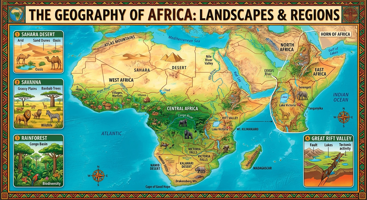
Africa is the second-largest continent by land area and one of the most geographically diverse regions on Earth. Its geography encompasses enormous deserts, tropical rainforests, grasslands, highlands, mountains, river systems, lakes, extensive coastlines, islands, fertile agricultural zones, mineral-rich regions, and rapidly growing cities. Geography has profoundly influenced African civilizations, migration, agriculture, trade, political boundaries, economic development, biodiversity, and patterns of human settlement.
Africa’s physical geography is characterized by large plateaus, relatively limited lowland areas, major drainage basins, and extensive climatic variation. The continent stretches across the Equator and reaches into both the Northern and Southern Hemispheres, producing a remarkable sequence of climatic and ecological zones. The Sahara dominates North Africa, while the Sahel forms a semi-arid transition zone farther south. Tropical forests occupy parts of Central Africa, especially around the Congo Basin, while savannas cover enormous areas of eastern, western, central, and southern Africa. Southern Africa contains major plateaus, deserts, semi-arid landscapes, and mountain systems.
Africa’s geography is inseparable from its water resources. Major rivers—including the Nile, Congo, Niger, Zambezi, Orange, Senegal, and Limpopo—and lakes such as Victoria, Tanganyika, Malawi, and Chad support agriculture, fisheries, transportation, ecosystems, cities, and industries. Many African river basins cross international borders, making transboundary water cooperation particularly important. The World Bank notes that Africa contains numerous transboundary river basins and that water systems frequently cross national boundaries.
At the same time, geography presents significant challenges. Drought, floods, desertification, coastal erosion, land degradation, water scarcity, and climate variability affect communities across different regions. Africa’s future development therefore depends partly on how effectively its societies manage land, water, ecosystems, cities, infrastructure, and natural resources.
1. Introduction
Geography is the study of places, environments, landscapes, spatial relationships, human populations, and interactions between people and the physical world.
The geography of Africa is particularly important because the continent contains extraordinary physical and human diversity within a single broad landmass.
Africa includes:
- deserts and semi-deserts;
- tropical rainforests;
- savannas and grasslands;
- mountains and high plateaus;
- major river systems;
- enormous freshwater lakes;
- Mediterranean-type environments;
- long Atlantic and Indian Ocean coastlines;
- islands and archipelagos;
- fertile agricultural regions;
- mineral-rich geological formations;
- rapidly expanding cities;
- highly diverse cultural and linguistic landscapes.
Geography has never been merely a description of Africa’s physical landscape. It has influenced where people live, what they produce, how communities interact, where cities develop, how trade routes emerge, and how states manage natural resources.
Understanding Africa therefore requires studying both physical geography and human geography.
2. Africa’s Geographic Position
Africa occupies a central position in the global geographic system.
The continent is crossed by the:
- Equator;
- Tropic of Cancer;
- Tropic of Capricorn;
- Prime Meridian.
This gives Africa an unusual north-south geographic structure.
The Equator crosses Central Africa, while large portions of the continent extend into both tropical and subtropical latitudes.
Africa is bordered by:
- the Mediterranean Sea to the north;
- the Atlantic Ocean to the west;
- the Indian Ocean to the east and southeast;
- the Red Sea and Gulf of Aden to the northeast.
The continent is connected geographically to Asia through the northeastern region around Egypt and the Sinai Peninsula, although the Suez Canal has created an important modern maritime boundary between Africa and Asia.
3. Size and Shape
Africa is enormous, covering roughly 30 million square kilometres when the continent’s major islands are included.
Its shape is characterized by a relatively compact landmass compared with continents that have highly fragmented coastlines.
One consequence is that Africa has a relatively high proportion of land located far from the ocean.
This helps explain why large inland regions experience strong continental climatic influences.
The continent’s great size also means that environmental conditions vary enormously from one region to another.
For example:
North Africa → Sahara Desert
West Africa → Sahel and tropical zones
Central Africa → Congo rainforest
East Africa → highlands, savannas and the Great Rift Valley
Southern Africa → plateaus, deserts, savannas and Mediterranean-type environments
4. Major Geographic Regions of Africa
Africa is commonly divided into several broad geographic regions.
4.1 North Africa
North Africa includes countries such as:
- Algeria;
- Egypt;
- Libya;
- Morocco;
- Tunisia;
- Sudan.
The region is dominated geographically by the Sahara, Mediterranean coastal environments, mountain ranges, and the Nile Valley.
The Atlas Mountains occupy parts of Morocco, Algeria, and Tunisia.
Egypt is strongly shaped by the Nile River, which creates a narrow corridor of settlement through otherwise extremely arid territory.
4.2 West Africa
West Africa extends from the Atlantic coast toward the interior Sahel.
Important geographic features include:
- the Niger River;
- the Senegal River;
- the Volta system;
- the Guinea Highlands;
- the Sahel;
- coastal plains;
- tropical forests;
- savannas.
The Gulf of Guinea is one of the continent’s important coastal regions.
The geography of West Africa has supported agriculture, fishing, trade, urbanization, and historically important civilizations.
4.3 Central Africa
Central Africa contains some of the continent’s most important tropical ecosystems.
The Congo Basin is the dominant geographic feature.
It contains:
- extensive tropical rainforest;
- enormous river networks;
- wetlands;
- high biodiversity;
- major mineral resources.
The Congo River is one of the world’s great rivers by discharge and forms the central drainage system of the region.
4.4 East Africa
East Africa has some of Africa’s most spectacular physical geography.
It includes:
- the Great Rift Valley;
- Ethiopian Highlands;
- East African lakes;
- volcanic mountains;
- savannas;
- coastal plains;
- the Horn of Africa.
The region contains Mount Kilimanjaro, Mount Kenya, the Ethiopian Highlands, Lake Victoria, Lake Tanganyika, and Lake Malawi.
East Africa is also internationally famous for its wildlife landscapes and protected ecosystems.
4.5 Southern Africa
Southern Africa includes countries such as:
- South Africa;
- Namibia;
- Botswana;
- Zimbabwe;
- Zambia;
- Mozambique;
- Angola;
- Malawi;
- Lesotho;
- Eswatini.
The region contains extensive plateaus, savannas, deserts, mountains, coastal environments, and major river systems.
Important physical features include:
- Kalahari;
- Namib Desert;
- Drakensberg;
- Highveld;
- Great Escarpment;
- Zambezi River;
- Orange River;
- Limpopo River.
5. The African Plateau
One of the defining characteristics of African physical geography is the dominance of elevated plateaus.
Africa is often described as a continent of plateaus rather than extensive lowland plains.
Large areas are elevated above sea level, with relatively narrow coastal lowlands in many locations.
This topography influences:
- rainfall;
- river systems;
- agriculture;
- transportation;
- settlement;
- hydroelectric development;
- temperature.
The eastern and southern parts of Africa contain particularly important highland and plateau systems.
6. Mountains of Africa
Africa contains numerous mountain systems and volcanic peaks.
Major examples include:
Atlas Mountains
Located in northwestern Africa, the Atlas Mountains extend through Morocco, Algeria, and Tunisia.
Ethiopian Highlands
The Ethiopian Highlands form one of Africa’s largest elevated regions and are sometimes described as the “Roof of Africa.”
They strongly influence regional rainfall and river systems.
East African Mountains
East Africa contains major volcanic mountains, including:
- Mount Kilimanjaro;
- Mount Kenya;
- the Rwenzori Mountains.
Drakensberg
The Drakensberg forms a major mountain and escarpment system in southern Africa, especially in South Africa and Lesotho.
Virunga Mountains
The Virunga volcanic region lies around the borders of Rwanda, Uganda, and the Democratic Republic of the Congo.
7. The Great Rift Valley
The Great Rift Valley is one of Africa’s most important geological and geographical structures.
It forms part of a much larger tectonic system created by the movement and separation of Earth’s crustal plates.
The East African Rift contains:
- deep valleys;
- volcanic mountains;
- escarpments;
- lakes;
- geothermal resources;
- fertile volcanic soils in some areas.
The region is also associated with major geological activity.
Its lakes include:
- Lake Turkana;
- Lake Tanganyika;
- Lake Malawi;
- Lake Albert;
- Lake Edward.
The Rift Valley has enormous significance for geology, ecology, agriculture, tourism, and human settlement.
8. African Deserts
Africa contains some of the world’s largest and most important deserts.
8.1 Sahara Desert
The Sahara is the world’s largest hot desert.
It stretches across much of North Africa.
It covers portions of countries including:
- Algeria;
- Chad;
- Egypt;
- Libya;
- Mali;
- Mauritania;
- Morocco;
- Niger;
- Sudan;
- Tunisia.
The Sahara is not simply a landscape of sand dunes. It contains:
- rocky plateaus;
- gravel plains;
- mountains;
- depressions;
- oases;
- dry valleys.
Its geography has strongly influenced migration, trade, settlement, and cultural interaction.
8.2 Kalahari
The Kalahari occupies parts of southern Africa, particularly Botswana, Namibia, and South Africa.
It is better understood as a predominantly semi-arid sandy region rather than a completely barren desert.
Vegetation and wildlife occur across substantial portions of the Kalahari.
8.3 Namib Desert
The Namib Desert extends along the Atlantic coast of southwestern Africa.
It is particularly famous for:
- extremely dry conditions;
- massive sand dunes;
- coastal fog;
- specialized plants and animals;
- dramatic landscapes.
The cold Benguela Current contributes significantly to the region’s aridity.
9. The Sahel
Between the Sahara and the more humid savannas to the south lies the Sahel.
The Sahel is a transitional zone rather than a sharply defined line.
It extends broadly across Africa from the Atlantic region toward the Red Sea.
Its environment is characterized by:
- semi-arid grasslands;
- shrublands;
- seasonal rainfall;
- pastoralism;
- agriculture;
- recurrent drought risks.
The World Bank describes the Sahel as a transitional ecoregion situated between the Sahara to the north and Sudanian savannas farther south.
The region is highly sensitive to rainfall variability.
10. African Rainforests
Central Africa contains the Congo Basin rainforest, one of Earth’s great tropical forest systems.
The Congo Basin is geographically important because it contains:
- enormous forest areas;
- major rivers;
- wetlands;
- carbon-rich ecosystems;
- extraordinary biodiversity.
The forest also contributes to regional rainfall and supports millions of people through agriculture, forestry, fishing, and other activities.
Forest geography therefore has implications far beyond biodiversity.
11. African Savannas
Savannas cover enormous areas of Africa.
They generally consist of:
- grasses;
- scattered trees;
- seasonal rainfall;
- large herbivore populations;
- predators;
- agricultural landscapes.
Important savanna regions occur in:
- East Africa;
- West Africa;
- Central Africa;
- southern Africa.
The Serengeti-Mara ecosystem is one of the best-known examples.
Savannas are especially important for:
- livestock;
- crop production;
- wildlife;
- tourism;
- ecosystem services.
12. Africa’s Major Rivers
Africa possesses several major river systems.
12.1 Nile
The Nile is one of the world’s most famous rivers.
Its basin extends across a large portion of northeastern and eastern Africa.
The Nile is fundamental to:
- agriculture;
- drinking water;
- cities;
- ecosystems;
- transport;
- energy production.
The Nile Basin crosses 11 countries, according to the World Bank.
12.2 Congo River
The Congo River drains a huge portion of Central Africa.
It is especially significant for:
- freshwater resources;
- rainforest ecosystems;
- fisheries;
- transportation;
- hydropower potential.
12.3 Niger River
The Niger is one of West Africa’s major rivers.
It supports:
- agriculture;
- fishing;
- settlements;
- irrigation;
- transportation.
Its unusual curved course makes it one of Africa’s distinctive river systems.
12.4 Zambezi River
The Zambezi flows through southern Africa.
It is important for:
- hydropower;
- agriculture;
- fisheries;
- ecosystems;
- tourism.
The Zambezi Basin is shared by several countries, demonstrating the importance of transboundary water management.
12.5 Orange River
The Orange River is one of southern Africa’s important river systems.
It is significant for:
- irrigation;
- water supply;
- hydropower;
- agriculture;
- industry.
13. Great Lakes of Africa
Africa contains several enormous freshwater lakes.
Important examples include:
- Lake Victoria;
- Lake Tanganyika;
- Lake Malawi;
- Lake Turkana;
- Lake Albert;
- Lake Edward;
- Lake Chad.
Lake Victoria
Lake Victoria is Africa’s largest lake by surface area and one of the world’s largest freshwater lakes.
It is economically and socially important to communities in Uganda, Kenya, and Tanzania.
Lake Tanganyika
Lake Tanganyika is extraordinarily deep and contains remarkable aquatic biodiversity.
It borders:
- Tanzania;
- the Democratic Republic of the Congo;
- Burundi;
- Zambia.
Lake Malawi
Lake Malawi is an important freshwater ecosystem and supports fisheries, agriculture, tourism, and local communities.
14. Climate Geography
Africa contains an extraordinary range of climates.
The World Bank’s analysis of African water resources emphasizes the continent’s considerable geographic climate variation and the fact that river basins frequently cross both national and climatic boundaries.
Broad climate categories include:
- Equatorial;
- Tropical wet and dry;
- Semi-arid;
- Desert;
- Mediterranean;
- Highland;
- Subtropical and temperate environments.
15. Equatorial Climate
Near the Equator, especially in parts of Central Africa, temperatures remain relatively high throughout the year.
Rainfall is generally abundant.
This climate supports:
- dense forests;
- wetlands;
- enormous biodiversity;
- intensive biological productivity.
The Congo Basin is the most important example.
16. Tropical Savanna Climate
Tropical savanna environments generally experience:
- wet seasons;
- dry seasons;
- grasslands;
- scattered trees.
They occupy enormous parts of Africa.
Their seasonal nature has strongly influenced pastoralism and agricultural systems.
17. Desert Climate
Desert environments occur primarily in:
- the Sahara;
- southwestern Africa;
- parts of the Horn of Africa.
Rainfall is extremely limited, and water availability strongly determines settlement.
Oases, groundwater systems, seasonal rivers, and irrigated agricultural zones become particularly important.
18. Mediterranean Climate
Mediterranean-type climates occur mainly in:
- northern coastal Africa;
- parts of southwestern South Africa.
They generally feature:
- relatively dry summers;
- wetter winters;
- conditions suitable for certain grains, fruits, vegetables, and other crops.
19. Highland Climate
Altitude modifies climate across Africa.
Highland regions may be considerably cooler than surrounding lowlands.
Examples include:
- Ethiopian Highlands;
- Kenyan highlands;
- Lesotho;
- parts of Rwanda and Burundi;
- eastern and southern African mountain areas.
Altitude influences agriculture, ecosystems, settlement, and human health.
20. Vegetation Geography
African vegetation generally follows climatic patterns.
Major vegetation zones include:
| Geographic environment | Typical vegetation |
|---|---|
| Equatorial rainforest | Dense evergreen forest |
| Savanna | Grasses and scattered trees |
| Sahel | Grass, shrubs and drought-resistant plants |
| Sahara | Sparse desert vegetation |
| Mediterranean zones | Shrublands, grasses and cultivated vegetation |
| Highland regions | Montane vegetation |
| Semi-arid southern Africa | Bushveld, grassland and scrub |
However, human activity increasingly modifies natural vegetation.
Agriculture, urbanization, mining, logging, infrastructure, and grazing can transform landscapes.
21. Soil Geography
African soils vary enormously.
Important soil environments include:
- tropical soils;
- volcanic soils;
- desert soils;
- alluvial soils;
- savanna soils;
- Mediterranean soils;
- highland soils.
Volcanic soils in parts of East Africa can be highly productive.
River valleys and floodplains can also contain fertile alluvial soils.
However, soil fertility is not determined solely by climate. Organic matter, geology, erosion, land management, water availability, and agricultural practices all matter.
22. Coastal Geography
Africa has extensive coastlines along the Atlantic and Indian oceans as well as the Mediterranean and Red seas.
Major coastal regions include:
- Gulf of Guinea;
- Mediterranean coast;
- Red Sea coast;
- East African coast;
- southern Atlantic coast;
- southeastern African coast.
Coastal environments include:
- beaches;
- mangroves;
- lagoons;
- deltas;
- estuaries;
- coral reefs;
- coastal forests.
West African coastal geography demonstrates the complexity of these systems. The World Bank notes that waves, currents, sediment, hydrology, geology, tectonic processes, and human intervention all influence coastal environments.
23. Islands of Africa
Africa’s geography includes numerous islands.
Important examples include:
- Madagascar;
- Mauritius;
- Seychelles;
- Comoros;
- Cabo Verde;
- São Tomé and Príncipe;
- Zanzibar and other islands of Tanzania.
Madagascar
Madagascar is particularly important because of its extraordinary biodiversity and geographic isolation.
Its isolation has produced many species found nowhere else on Earth.
24. Population Geography
Africa’s population is distributed unevenly.
Dense settlement tends to occur where there is:
- reliable water;
- fertile land;
- favorable climate;
- economic opportunity;
- transportation infrastructure;
- historical urban development.
Examples of densely populated areas include parts of:
- the Nile Valley and Delta;
- Gulf of Guinea;
- Ethiopian Highlands;
- Great Lakes region;
- southern African urban-industrial zones.
In contrast, population density is generally much lower in:
- Sahara;
- Namib;
- Kalahari;
- some remote rainforest regions.
25. Urban Geography
Africa is undergoing major urban transformation.
Large metropolitan areas include:
- Cairo;
- Lagos;
- Johannesburg;
- Kinshasa;
- Nairobi;
- Addis Ababa;
- Dar es Salaam;
- Luanda;
- Accra;
- Abidjan;
- Casablanca;
- Cape Town.
Urbanization is changing the geographic relationship between people, infrastructure, transportation, housing, water, energy, and employment.
Cities are increasingly becoming major centers of:
- technology;
- finance;
- manufacturing;
- education;
- government;
- transportation;
- innovation.
26. Agricultural Geography
Agriculture remains geographically important across Africa.
Different environments support different agricultural systems.
Humid regions
Produce crops such as:
- cocoa;
- bananas;
- cassava;
- oil palm;
- tropical fruits.
Savanna regions
Support:
- maize;
- sorghum;
- millet;
- livestock;
- groundnuts.
Highlands
Can support:
- coffee;
- tea;
- grains;
- vegetables;
- livestock.
Mediterranean regions
Support:
- wheat;
- olives;
- citrus;
- grapes;
- vegetables.
River valleys
Can support intensive irrigated agriculture.
27. Pastoral Geography
Livestock production is particularly important in dry and semi-arid regions.
Pastoral systems are common in:
- Sahel;
- Horn of Africa;
- East African savannas;
- southern African drylands.
Pastoralists often move livestock according to seasonal availability of:
- water;
- grass;
- pasture;
- agricultural residues.
Changes in rainfall and land use can significantly affect these systems.
28. Mineral Geography
Africa is geographically rich in mineral resources.
Major resources include:
- gold;
- copper;
- cobalt;
- platinum-group metals;
- iron ore;
- manganese;
- bauxite;
- uranium;
- lithium;
- diamonds;
- petroleum;
- natural gas.
Major mineral-producing regions include:
Southern Africa
Known for major deposits of:
- platinum-group metals;
- gold;
- diamonds;
- coal;
- manganese;
- iron ore.
Central Africa
The Copperbelt of Zambia and the Democratic Republic of the Congo is one of the world’s major copper and cobalt-producing regions.
West Africa
Important resources include:
- gold;
- bauxite;
- iron ore;
- petroleum.
North Africa
Important resources include:
- petroleum;
- natural gas;
- phosphates.
29. Energy Geography
Africa possesses enormous energy resources.
These include:
- solar;
- wind;
- hydropower;
- geothermal;
- natural gas;
- petroleum;
- coal;
- biomass.
The geography of renewable energy is particularly promising.
North Africa has vast solar potential.
Southern and eastern Africa contain significant solar and wind resources.
East Africa has exceptional geothermal potential associated with the Rift Valley.
Major river systems provide hydropower opportunities.
30. Transportation Geography
Africa’s physical geography presents both opportunities and obstacles for transportation.
Deserts, mountains, forests, wetlands, large rivers, and long distances can make infrastructure expensive.
Transportation networks include:
- highways;
- railways;
- ports;
- airports;
- inland waterways;
- pipelines.
Coastal cities often function as gateways connecting landlocked countries to international markets.
31. Economic Geography
Africa’s economies are geographically diverse.
Different regions specialize in different combinations of:
- agriculture;
- mining;
- energy;
- manufacturing;
- tourism;
- financial services;
- telecommunications;
- logistics;
- technology.
Geography creates both opportunities and constraints.
A country with access to ports may have advantages for international trade, while a landlocked country may face additional transportation costs.
However, infrastructure can change these geographic disadvantages.
Railways, highways, digital networks, ports, pipelines, electricity grids, and air transport can effectively reshape economic geography.
32. Tourism Geography
Africa’s geographical diversity makes it one of the world’s major tourism regions.
Tourism resources include:
Wildlife
- Serengeti;
- Maasai Mara;
- Kruger region;
- Okavango Delta.
Mountains
- Kilimanjaro;
- Atlas Mountains;
- Drakensberg.
Deserts
- Sahara;
- Namib;
- Kalahari.
Beaches
- East African coast;
- Indian Ocean islands;
- Mediterranean coast;
- southern African coastline.
Historical landscapes
Africa contains archaeological and historical sites associated with ancient civilizations, medieval states, colonial history, and modern nation-building.
33. Biodiversity Geography
Africa contains some of Earth’s most important biodiversity regions.
Major ecosystems include:
- Congo rainforest;
- East African savannas;
- Madagascar;
- Guinean forests;
- Miombo woodlands;
- Cape Floristic Region;
- wetlands of southern Africa.
Biodiversity provides:
- food;
- medicines;
- tourism;
- ecosystem services;
- pollination;
- water regulation;
- carbon storage;
- cultural value.
34. Geography and Human History
Geography has shaped African history for thousands of years.
The Nile Valley supported ancient Egyptian civilization.
West African river systems supported powerful historical states.
The Sahel became a major zone of trans-Saharan trade.
East African coastal geography supported Indian Ocean commerce.
Southern African landscapes influenced pastoralism, agriculture, mining, and settlement.
Thus, African history cannot be fully understood without understanding African geography.
35. Geography and Language
Africa is one of the world’s most linguistically diverse continents.
Language distributions reflect:
- migration;
- trade;
- settlement;
- historical state formation;
- cultural interaction.
Major language families include:
- Niger-Congo;
- Afroasiatic;
- Nilo-Saharan, as traditionally classified;
- Khoisan language groupings, a broad and debated category;
- Austronesian languages in Madagascar.
European languages such as English, French, Portuguese, and Spanish also became important through colonial history and remain official or widely used in many states.
36. Political Geography
Modern Africa is divided into sovereign states with internationally recognized boundaries.
Political borders, however, do not always correspond to:
- ethnic distributions;
- language regions;
- ecological zones;
- river basins;
- historical territories;
- trade networks.
This is particularly important for understanding transboundary issues.
A river can cross several countries.
A pastoral route can cross political boundaries.
A forest ecosystem can extend across multiple states.
Consequently, many African geographic problems require regional cooperation.
37. Transboundary Geography
Africa contains numerous shared ecosystems and water systems.
Examples include:
- Nile Basin;
- Congo Basin;
- Niger Basin;
- Senegal Basin;
- Volta Basin;
- Zambezi Basin;
- Lake Chad Basin;
- Okavango Basin.
The World Bank has noted that Africa contains dozens of transboundary river basins and that shared water resources create a strong need for cooperation.
This is one of the most important principles of modern African geography:
Natural geography does not follow political borders.
38. Environmental Challenges
Africa faces a diverse collection of environmental pressures.
These include:
- drought;
- floods;
- desertification;
- land degradation;
- deforestation;
- biodiversity loss;
- coastal erosion;
- soil erosion;
- water scarcity;
- pollution;
- invasive species;
- climate change.
The geographic impact differs significantly between regions.
The Sahel, for example, faces different risks from coastal West Africa, the Congo Basin, or southern African drylands.
39. Climate Change and African Geography
Climate change is increasingly influencing African geography.
Observed and projected challenges include:
- rising temperatures;
- changing rainfall patterns;
- drought;
- flooding;
- coastal erosion;
- sea-level rise;
- agricultural stress;
- water insecurity.
The World Bank has highlighted floods, extreme heat, coastal erosion, land degradation, and other climate shocks as major challenges across parts of Africa.
Africa’s geography makes climate adaptation particularly important because many communities depend heavily on climate-sensitive activities such as agriculture, pastoralism, fisheries, and natural-resource-based livelihoods.
40. Coastal Geography and Sea-Level Rise
Africa has numerous densely populated coastal regions.
Important coastal cities include:
- Lagos;
- Accra;
- Abidjan;
- Alexandria;
- Dar es Salaam;
- Maputo;
- Cape Town;
- Durban;
- Mombasa.
Coastal areas face risks associated with:
- erosion;
- flooding;
- storms;
- sea-level rise;
- saltwater intrusion;
- ecosystem degradation.
Coastal planning will therefore become increasingly important.
41. Water Geography
Water is one of Africa’s most strategically important geographic resources.
Water availability is highly uneven.
Some regions contain abundant rainfall and enormous rivers, while others are extremely dry.
The challenge is not simply the total amount of water available. It also involves:
- seasonal distribution;
- storage;
- infrastructure;
- groundwater;
- water quality;
- population distribution;
- agricultural demand;
- industrial demand.
This explains why dams, reservoirs, irrigation systems, water-transfer projects, groundwater management, and transboundary agreements are so important.
42. The Geographic Importance of the Congo Basin
The Congo Basin deserves special attention.
It is simultaneously:
- a rainforest;
- a river basin;
- a biodiversity center;
- a carbon-rich ecosystem;
- a livelihood system;
- a potential economic resource;
- a regional climate regulator.
The Congo Basin therefore represents the interconnected nature of African geography.
Forest geography, water geography, climate geography, biodiversity, economics, and human settlement all meet within the same system.
43. Geography of Food Security
Food security is strongly influenced by geography.
Agricultural productivity depends on:
- rainfall;
- temperature;
- soils;
- water;
- pests;
- terrain;
- transportation;
- markets;
- technology.
Climate variability can create major differences between agricultural seasons.
Irrigation and improved water management can reduce some of this variability, although they require investment and careful environmental management.
44. Geography of Infrastructure
Infrastructure development is fundamentally geographic.
Africa’s infrastructure requirements include:
- electricity networks;
- roads;
- railways;
- ports;
- airports;
- dams;
- irrigation;
- telecommunications;
- data centers;
- water systems;
- sanitation.
Geography determines where infrastructure should be built and how expensive construction may be.
Mountainous, desert, rainforest, and wetland environments each present different engineering challenges.
45. Digital Geography of Africa
Modern geography is no longer limited to physical infrastructure.
Africa’s digital geography is increasingly important.
It includes:
- mobile networks;
- fiber-optic cables;
- internet exchanges;
- cloud infrastructure;
- data centers;
- satellite systems;
- digital financial networks;
- technology hubs.
Major cities increasingly function as digital gateways.
This creates new geographic relationships between African economies and the global digital economy.
46. Geography and the Future of African Cities
African urban geography will become increasingly important as populations and economic activity become more concentrated in cities.
Future planning must address:
- housing;
- transportation;
- water;
- electricity;
- sanitation;
- waste management;
- digital infrastructure;
- green spaces;
- flood management;
- climate resilience.
Urban geography will therefore become a central part of Africa’s development strategy.
47. Geographic Opportunities for Africa
Africa’s geography provides enormous opportunities.
These include:
Renewable energy
Large solar, wind, hydroelectric, and geothermal resources.
Agriculture
Large areas of cultivable land and diverse climates.
Mining
Extensive deposits of minerals essential to modern industries.
Tourism
Exceptional wildlife, landscapes, beaches, mountains, deserts, and cultural heritage.
Blue economy
Extensive marine and coastal resources.
Forestry
Important forest ecosystems with economic and environmental value.
Digital economy
A young and increasingly connected population combined with rapidly expanding telecommunications infrastructure.
48. Geographic Challenges Requiring Continental Cooperation
Many geographic challenges cannot be solved by individual countries alone.
Examples include:
- river-basin management;
- desertification;
- climate adaptation;
- wildlife conservation;
- cross-border transportation;
- electricity interconnection;
- disease surveillance;
- coastal management;
- migration;
- food systems.
Regional institutions and cooperation therefore have a major geographic role.
49. A Geographic Framework for Africa’s Development
A useful development framework can be built around seven geographic systems:
1. Land
Protect and improve agricultural and ecological landscapes.
2. Water
Develop sustainable systems for rivers, groundwater, reservoirs, and irrigation.
3. Energy
Use Africa’s diverse energy resources to support industrialization.
4. Infrastructure
Connect cities, rural areas, ports, markets, and neighboring countries.
5. People
Invest in education, health, skills, and urban development.
6. Nature
Protect forests, wetlands, grasslands, biodiversity, and coastal systems.
7. Digital connectivity
Connect physical geography to the global digital economy.
50. Conclusion
The geography of Africa is far more complex than the familiar image of a continent dominated by deserts and wildlife.
Africa is a continent of extraordinary geographic contrasts.
It contains:
- the Sahara Desert;
- the Congo rainforest;
- the Nile Valley;
- the Great Rift Valley;
- vast savannas;
- major mountain systems;
- enormous freshwater lakes;
- important river basins;
- productive agricultural regions;
- mineral-rich geological formations;
- extensive coastlines;
- islands with unique ecosystems;
- rapidly expanding cities.
These geographic characteristics have shaped African civilization throughout history.
The continent’s rivers supported agriculture and cities. Its deserts influenced migration and trade. Its savannas supported pastoralism and agriculture. Its forests created distinctive ecological and economic systems. Its mountains influenced rainfall and settlement. Its coastlines connected African societies to global maritime networks.
Today, geography remains fundamental to Africa’s future.
Climate change, urbanization, water security, infrastructure development, agricultural transformation, energy production, mineral demand, biodiversity conservation, and digital connectivity are all geographic questions as well as economic and political ones.
Perhaps the most important lesson is that Africa should be understood as a collection of interconnected geographic systems rather than as a single uniform environment.
The Sahara cannot be understood separately from the Sahel. The Sahel cannot be understood separately from West African rainfall systems. The Congo rainforest cannot be separated from the Congo River Basin. East African agriculture cannot be separated from the Rift Valley and highlands. Southern African development cannot be separated from its plateaus, rivers, minerals, deserts, coasts, and urban-industrial corridors.
Africa’s geography is therefore both a record of its past and a foundation for its future.
The continent’s greatest opportunity lies not simply in possessing enormous natural resources, but in developing the knowledge, infrastructure, institutions, technology, and regional cooperation required to manage those resources sustainably.
In the twenty-first century, understanding African geography means understanding the relationship between land, water, climate, people, cities, resources, ecosystems, infrastructure, technology, and economic development.
That relationship will play a decisive role in determining Africa’s environmental resilience, economic transformation, and quality of life for generations to come.
Selected References and Further Reading
- World Bank — Africa’s Water Resources in a Changing Climate.
- World Bank — Nile Cooperation for Climate Resilience.
- World Bank — Human Interventions and Climate Change Impacts on the West African Coast.
- World Bank — Climate and Development in the G5 Sahel.
- World Bank — Transboundary Water Cooperation Helps Build Climate Resilience.
- World Bank — Sharing Waters, Transforming Futures: CIWA’s Action for a Climate-Resilient Africa.
- World Bank — 3 Key Fronts on Which Africa Must Combat Climate Change.



Be First to Comment